Skip to content

Case Study

Introducing the NORBIT WINGHEAD i80S Long Range Multibeam Sonar

Have a question?

Contact our global subsea team

Published

Introduction

This case study highlights the key features of the NORBIT WINGHEAD i80S Long Range multibeam sonar mapping system.

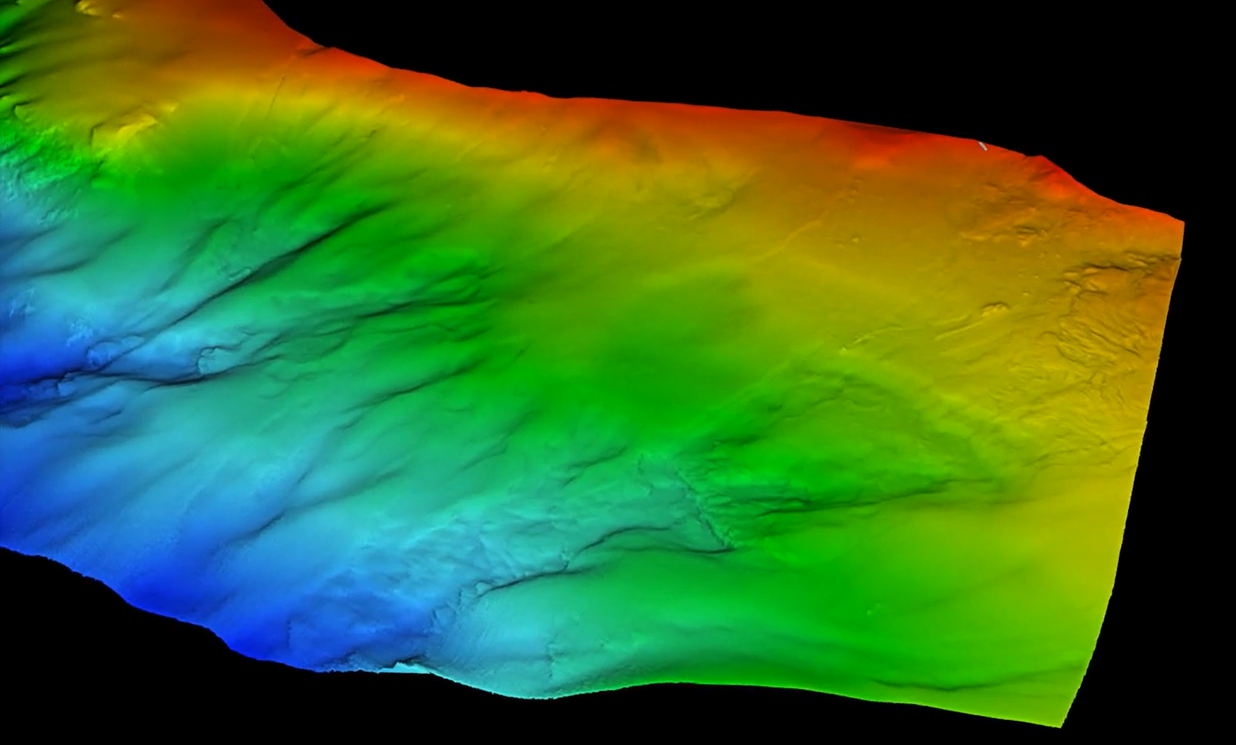
To test the sonar’s range performance, target detection and data quality, a 4.5km2 area was surveyed across a wide range of depths from 5m to 340m. The survey was performed in the diverse and challenging environment of the Trondheim Fjord in Norway.

The results demonstrate the sonar’s versatile capabilities, delivering high-resolution data with wide swath coverage in a range of underwater environments.

Equipment used:

  • NORBIT WINGHEAD i80S Long Range with integrated Applanix OceanMaster GNSS/INS and SV sensor
  • NORBIT Sound Velocity Profiler
  • NORBIT PORTUS Pole Mount
NORBIT WINGHEAD i80S multibeam sonar with integrated GNSS-inertial positioning and Trimble antennas
The NORBIT WINGHEAD i80S long-range multibeam sonar together with the Survey Interface Unit (SIU) and Trimble GNSS antennas.​​​​‌‍​‍​‍‌‍‌​‍‌‍‍‌‌‍‌‌‍‍‌‌‍‍​‍​‍​‍‍​‍​‍‌​‌‍​‌‌‍‍‌‍‍‌‌‌​‌‍‌​‍‍‌‍‍‌‌‍​‍​‍​‍​​‍​‍‌‍‍​‌​‍‌‍‌‌‌‍‌‍​‍​‍​‍‍​‍​‍‌‍‍​‌‌​‌‌​‌​​‌​​‍‍​‍​‍‌‍‍‌‍‌​‍‌‍​‍‌‍‍‌‌‌​​‍‍‌‍‌‍‌​‍‌‍‌‍‍‌‌​‌‍‌‌‌‍‍‌‍‌​​‍‍‌‍‍‌‌‍‍‌‍​‌​‍‌‍‌‌‌‍​‍‍‌​‌​​‌‍​‌‌‍​‌‍‌‌​‍‌​‌‌​‌‌‌‌‍‌​‌‍‍‌‌‍​‍‌‍‍‌‌‍‍‌‌​‌‍‌‌‌‍‍‌‌​​‍‌‍‌‌‌‍‌​‌‍‍‌‌‌​​‍‌‍‌‌‍‌‍‌​‌‍‌‌​‌‌​​‌​‍‌‍‌‌‌​‌‍‌‌‌‍‍‌‌​‌‍​‌‌‌​‌‍‍‌‌‍‌‍‍​‍‌‍‍‌‌‍‌​​‌‌‍‍‌‌‍‌‌‍​‌‌‍‌‌‍‌‌​‍‌‌‍​‌‍​​‍‌‌‍​​‍​‌‍‌‍​​‌‍‌‌​​​​‌‌​​​​​‍​‍​​‍‌​‍​‌‍​​​‍​​‌‍‌‌​​‍​‍‌‌‍​‌​‌‌​​​​​‍​‌‌‌‍​‌‍​​​‌‍‌‍‌‍​​​​‌‌​‌‍‌‍‌​​‌‍​‌‌‍‌​​‌‌‌‍‌‌​‍‌​‍‌​​​‍‌‌‍​​​‌​​‍​​​​‌‌​‍‌‌​​‌‍‍‌‍‌​‍‌‌​‌‍‌‌​​‌‍‌‌​‌‌​‌‍​‌‌‍‍‌‍‍‌‌‌​‌‍‌​‍‍‌‍‍‌‌‍‌‌‍​‌‌‍‌‌‍‌‌‌​​‌‌​‌​‌‍‌‌‌‌​​‍‌​​‌‍​‌‌‌​‌‍‍​​‌‌‍‌​‌‍‌‌‌​‌‍​‌​‍‌‍‍‌‌​​‌‌​‌‍‍‌‌‍‌‍‍​‌‍​‍‌‍​‌‌​‌‍‌‌‌‌‌‌‌​‍‌‍​​‌‌‍‍​‌‌​‌‌​‌​​‌​​‍‌‌​​‌​​‌​‍‌‌​​‍‌​‌‍​‍‌‌​​‍‌​‌‍‌‍‍‌‍‌​‍‌‍​‍‌‍‍‌‌‌​​‍‍‌‍‌‍‌​‍‌‍‌‍‍‌‌​‌‍‌‌‌‍‍‌‍‌​​‍‍‌‍‍‌‌‍‍‌‍​‌​‍‌‍‌‌‌‍​‍‍‌​‌​​‌‍​‌‌‍​‌‍‌‌​‍‌‌​​‍‌​‌‍‌​‌‌​‌‌‌‌‍‌​‌‍‍‌‌‍​‍‌‍‌‍‍‌‌‍‌​​‌‌‍‍‌‌‍‌‌‍​‌‌‍‌‌‍‌‌​‍‌‌‍​‌‍​​‍‌‌‍​​‍​‌‍‌‍​​‌‍‌‌​​​​‌‌​​​​​‍​‍​​‍‌​‍​‌‍​​​‍​​‌‍‌‌​​‍​‍‌‌‍​‌​‌‌​​​​​‍​‌‌‌‍​‌‍​​​‌‍‌‍‌‍​​​​‌‌​‌‍‌‍‌​​‌‍​‌‌‍‌​​‌‌‌‍‌‌​‍‌​‍‌​​​‍‌‌‍​​​‌​​‍​​​​‌‌​‍‌‌​​‌‍‍‌‍‌​‍‌‍‌‌​‌‍‌‌​​‌‍‌‌​‌‌​‌‍​‌‌‍‍‌‍‍‌‌‌​‌‍‌​‍‍‌‍‍‌‌‍‌‌‍​‌‌‍‌‌‍‌‌‌​​‌‌​‌​‌‍‌‌‌‌​​‍‌‍‌​​‌‍​‌‌‌​‌‍‍​​‌‌‍‌​‌‍‌‌‌​‌‍​‌​‍‌‍‍‌‌​​‌‌​‌‍‍‌‌‍‌‍‍​‍‌‍‌​​‌‍‌‌‌​‍‌​‌​​‌‍‌‌‌‍​‌‌​‌‍‍‌‌‌‍‌‍‌‌​‌‌​​‌‌‌‌‍​‍‌‍​‌‍‍‌‌​‌‍‍​‌‍‌‌‌‍‌​​‍​‍‌‌

The WINGHEAD i80S Long Range Multibeam Sonar


The WINGHEAD i80S Long Range Multibeam Sonar is a compact, fully integrated multibeam survey system offering 0.5×0.9° beam widths at 400kHz and 1.0×1.8° at 200kHz.

NORBIT’s steerable transmission technology provides full motion stabilisation (roll, pitch and yaw) to ensure uniform sounding coverage in dynamic sea states.

Key features:

  • The Echo sounder is frequency agile from 200-700kHz, and generates 1024 dynamically focused beams per ping.
  • Has up to 600m range performance.
  • The IMU is tightly embedded within the sonar head.
  • Dual Swath provides up to 2048 beams, allowing higher sounding density and reduced survey time.
  • The system weighs 8.0kg in air and connects to a compact topside unit via a single cable, allowing rapid mobilisation.
Marmel survey vessel equipped with NORBIT WINGHEAD i80S

Installation and setup

The sonar was mounted on NORBIT’s vessel, MARMEL, using the NORBIT PORTUS mounting pole. The sonar’s compact size allowed for easy transportation to the vessel, as the entire system, including cable, conveniently fits into a single Pelican Case.

Rapid mobilisation

The single-cable solution enabled rapid mobilisation, allowing the system to be quickly deployed and operational within minutes.

The fixed and known offsets of the NORBIT PORTUS pole, combined with the wizard-based INS setup tools, ensured a quick and easy setup. This streamlined installation process simplifies the learning curve for less experienced surveyors, minimising complexity and reducing the risk of operator error.

Screenshot of the interface of the INS setup wizard‌ used
Screenshot of the interface of the INS setup wizard‌ used ‍​‍​‍‌‍‌​‍‌‍‍‌‌‍‌‌‍‍‌‌‍‍​‍​‍​‍‍​‍​‍‌​‌‍​‌‌‍‍‌‍‍‌‌‌​‌‍‌​‍‍‌‍‍‌‌‍​‍​‍​‍​​‍​‍‌‍‍​‌​‍‌‍‌‌‌‍‌‍​‍​‍​‍‍​‍​‍‌‍‍​‌‌​‌‌​‌​​‌​​‍‍​‍​‍‌‍‍‌‍‌​‍‌‍​‍‌‍‍‌‌‌​​‍‍‌‍‌‍‌​‍‌‍‌‍‍‌‌​‌‍‌‌‌‍‍‌‍‌​​‍‍‌‍‍‌‌‍‍‌‍​‌​‍‌‍‌‌‌‍​‍‍‌​‌​​‌‍​‌‌‍​‌‍‌‌​‍‌​‌‌​‌‌‌‌‍‌​‌‍‍‌‌‍​‍‌‍‍‌‌‍‍‌‌​‌‍‌‌‌‍‍‌‌​​‍‌‍‌‌‌‍‌​‌‍‍‌‌‌​​‍‌‍‌‌‍‌‍‌​‌‍‌‌​‌‌​​‌​‍‌‍‌‌‌​‌‍‌‌‌‍‍‌‌​‌‍​‌‌‌​‌‍‍‌‌‍‌‍‍​‍‌‍‍‌‌‍‌​​‌‌‍‍‌‌‍‌‌‍​‌‌‍‌‌‍‌‌​‍‌​​​​‌‍‌‍‌‍‌‍​‌‍‌‌‌‍​‍​‌‍‌‍‌‍‌‍​‌‍‌‍​​​‌​‌‌‌‍‌​‌‍​‍​​‌‌‍​‍​‌‌‍​‌‍‌‌‌‍‌‍​‌​‌‍‌​‌‍‌‌‌‍​‌​‌‌‍‌‌‌‍‌‌​‌​​​‌​‍‌​‌‍‌‍​‌​‌‌‌‍​‌‍‌‌​‍‌​‍‌​​‌‌‍‌​​‍‌​​​‍​​‌‍​​‌‌‍​​​‍​‍​​‌​‌​‍‌‌​​‌‍‍‌‍‌​‍‌‌​‌‍‌‌​​‌‍‌‌​‌‌​‌‍​‌‌‍‍‌‍‍‌‌‌​‌‍‌​‍‍‌‍‍‌‌‍‌‌‍​‌‌‍‌‌‍‌‌‌​​‌‌​‌​‌‍‌‌‌‌​​‍‌​​‌‍​‌‌‌​‌‍‍​​‌‌‍‌​‌‍‌‌‌​‌‍​‌​‍‌‍‍‌‌​​‌‌​‌‍‍‌‌‍‌‍‍​‌‍​‍‌‍​‌‌​‌‍‌‌‌‌‌‌‌​‍‌‍​​‌‌‍‍​‌‌​‌‌​‌​​‌​​‍‌‌​​‌​​‌​‍‌‌​​‍‌​‌‍​‍‌‌​​‍‌​‌‍‌‍‍‌‍‌​‍‌‍​‍‌‍‍‌‌‌​​‍‍‌‍‌‍‌​‍‌‍‌‍‍‌‌​‌‍‌‌‌‍‍‌‍‌​​‍‍‌‍‍‌‌‍‍‌‍​‌​‍‌‍‌‌‌‍​‍‍‌​‌​​‌‍​‌‌‍​‌‍‌‌​‍‌‌​​‍‌​‌‍‌​‌‌​‌‌‌‌‍‌​‌‍‍‌‌‍​‍‌‍‌‍‍‌‌‍‌​​‌‌‍‍‌‌‍‌‌‍​‌‌‍‌‌‍‌‌​‍‌​​​​‌‍‌‍‌‍‌‍​‌‍‌‌‌‍​‍​‌‍‌‍‌‍‌‍​‌‍‌‍​​​‌​‌‌‌‍‌​‌‍​‍​​‌‌‍​‍​‌‌‍​‌‍‌‌‌‍‌‍​‌​‌‍‌​‌‍‌‌‌‍​‌​‌‌‍‌‌‌‍‌‌​‌​​​‌​‍‌​‌‍‌‍​‌​‌‌‌‍​‌‍‌‌​‍‌​‍‌​​‌‌‍‌​​‍‌​​​‍​​‌‍​​‌‌‍​​​‍​‍​​‌​‌​‍‌‌​​‌‍‍‌‍‌​‍‌‍‌‌​‌‍‌‌​​‌‍‌‌​‌‌​‌‍​‌‌‍‍‌‍‍‌‌‌​‌‍‌​‍‍‌‍‍‌‌‍‌‌‍​‌‌‍‌‌‍‌‌‌​​‌‌​‌​‌‍‌‌‌‌​​‍‌‍‌​​‌‍​‌‌‌​‌‍‍​​‌‌‍‌​‌‍‌‌‌​‌‍​‌​‍‌‍‍‌‌​​‌‌​‌‍‍‌‌‍‌‍‍​‍‌‍‌​​‌‍‌‌‌​‍‌​‌​​‌‍‌‌‌‍​‌‌​‌‍‍‌‌‌‍‌‍‌‌​‌‌​​‌‌‌‌‍​‍‌‍​‌‍‍‌‌​‌‍‍​‌‍‌‌‌‍‌​​‍​‍‌‌

Results

The NORBIT WINGHEAD i80S Sonar demonstrated outstanding versatility during the trials in the Trondheim Fjord, performing well in both shallow and deep-water conditions.

Despite its compact size, the i80S delivered high-resolution bathymetric data and wide-swath coverage, confirming its versatility for a broad range of hydrographic survey applications.

From long-range coverage to fine-scale target detection, the system delivered consistent, high-quality bathymetric and backscatter data across the entire 4.5 km² survey area.

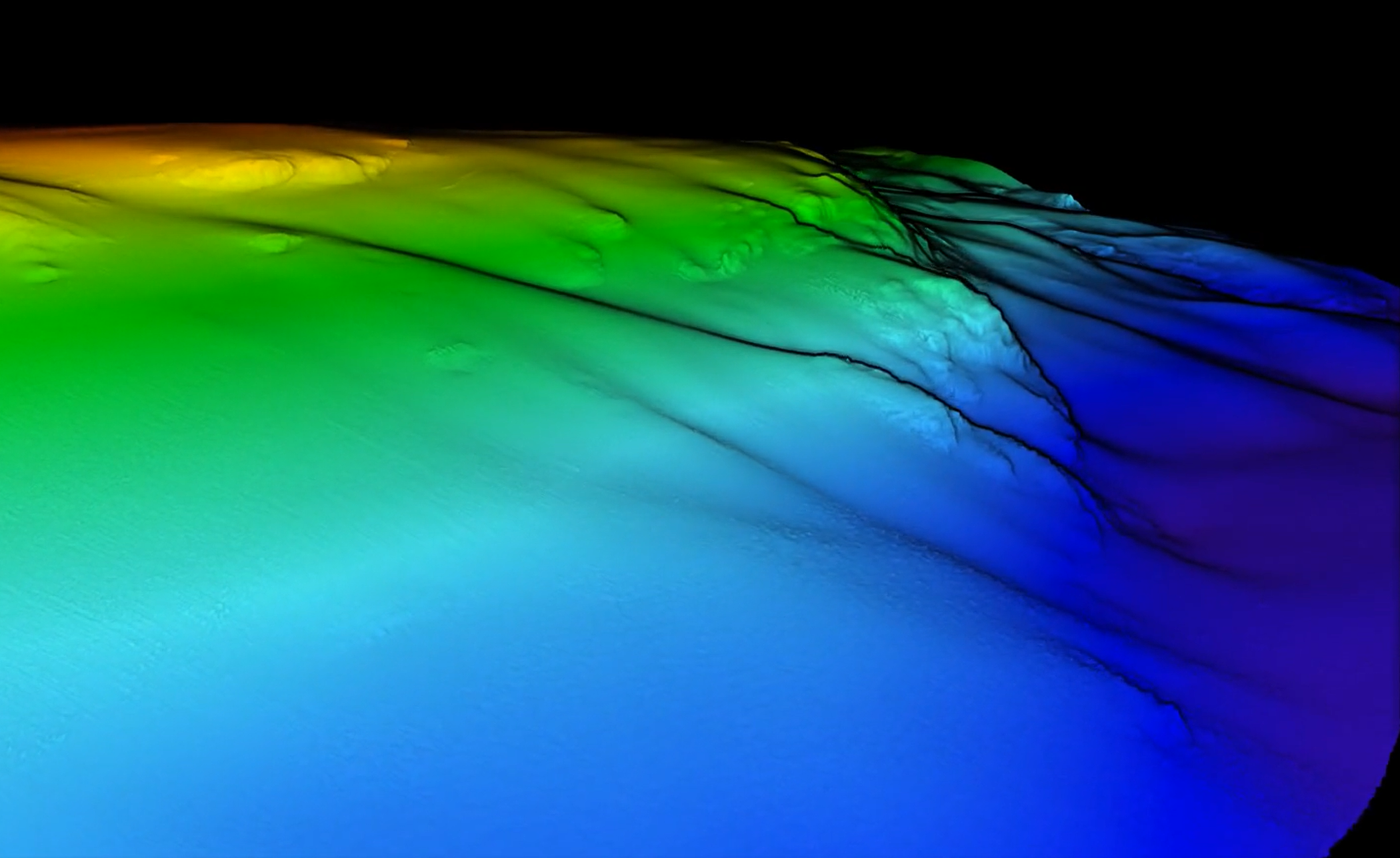
Range performance and coverage

The sonar excels at long-range detection, enabling wide swath coverage in deep waters. It transmits longer pulses in deep waters, providing optimal swath performance and significantly increasing coverage area.

Coverage greater than 2x water depth was achieved at 300m with an operating frequency of 200kHz. The frequency and pulse characteristics can be changed to suit different survey needs, providing versatility for both shallow water and deep-water operations without sacrificing data quality.

Shallow water target detection

The sonar can also operate at 700kHz, producing narrower beams (less than 0.3deg) for ultra-high resolution target mapping in shallow water.

As part of the product development, NORBIT has implemented new and improved detection algorithms to provide cleaner and more repeatable data with lower uncertainty.

Shipwreck bathymetric image and historical image.
The shipwreck surveyed and a historical image of the ship.

Deep Water Target Detection

This 700kHz point cloud data shows a Short Sunderland seaplane surveyed at a depth of 67m. It has rested at the bottom of the fjord since 1945 and measures 26m in length, with a wingspan of 36m.


The Short Sunderland seaplane wreck detected by WINGHEAD i80S sonar at 67 m depth, matched with a historical reference photo.​​​​‌‍​‍​‍‌‍‌​‍‌‍‍‌‌‍‌‌‍‍‌‌‍‍​‍​‍​‍‍​‍​‍‌​‌‍​‌‌‍‍‌‍‍‌‌‌​‌‍‌​‍‍‌‍‍‌‌‍​‍​‍​‍​​‍​‍‌‍‍​‌​‍‌‍‌‌‌‍‌‍​‍​‍​‍‍​‍​‍‌‍‍​‌‌​‌‌​‌​​‌​​‍‍​‍​‍‌‍‍‌‍‌​‍‌‍​‍‌‍‍‌‌‌​​‍‍‌‍‌‍‌​‍‌‍‌‍‍‌‌​‌‍‌‌‌‍‍‌‍‌​​‍‍‌‍‍‌‌‍‍‌‍​‌​‍‌‍‌‌‌‍​‍‍‌​‌​​‌‍​‌‌‍​‌‍‌‌​‍‌​‌‌​‌‌‌‌‍‌​‌‍‍‌‌‍​‍‌‍‍‌‌‍‍‌‌​‌‍‌‌‌‍‍‌‌​​‍‌‍‌‌‌‍‌​‌‍‍‌‌‌​​‍‌‍‌‌‍‌‍‌​‌‍‌‌​‌‌​​‌​‍‌‍‌‌‌​‌‍‌‌‌‍‍‌‌​‌‍​‌‌‌​‌‍‍‌‌‍‌‍‍​‍‌‍‍‌‌‍‌​​‌‌‍‍‌‌‍‌‌‍​‌‌‍‌‌‍‌‌​‍‌‌‍‌‌‌‍​​‌‌‌‍‌‍​​‌‌‍​‍‌‍‌‍‌‍‌‌‌‍​‍‌‍​​​​​​‍‌‍‌​​​​‌‍‌‍‌‌​‌‌‍​‍‌‍‌​‌‍​‍‌‍​​​​​​​‌‍​‌​‌‌​​‍‌‍‌‍​​‍​‌​‌‍​‌‌‍‌​‌‍​​‍‌​‍​‌‍‌​‌‍‌‍​​​​‍​​‌‌‍​​‍‌​​​‌​​‌‌​​‌‌‍​​​‌​​​​​‍​​‍‌‌‍‍‍‌​​‌‍‌​‍‌‌​‌‍‌‌​​‌‍‌‌​‌‌​‌‍​‌‌‍‍‌‍‍‌‌‌​‌‍‌​‍‍‌‍‍‌‌‍‌‌‍​‌‌‍‌‌‍‌‌‌​​‌‌​‌​‌‍‌‌‌‌​​‍‌​​‌‍​‌‌‌​‌‍‍​​‌‌‍‌​‌‍‌‌‌​‌‍​‌​‍‌‍‍‌‌​​‌‌​‌‍‍‌‌‍‌‍‍​‌‍​‍‌‍​‌‌​‌‍‌‌‌‌‌‌‌​‍‌‍​​‌‌‍‍​‌‌​‌‌​‌​​‌​​‍‌‌​​‌​​‌​‍‌‌​​‍‌​‌‍​‍‌‌​​‍‌​‌‍‌‍‍‌‍‌​‍‌‍​‍‌‍‍‌‌‌​​‍‍‌‍‌‍‌​‍‌‍‌‍‍‌‌​‌‍‌‌‌‍‍‌‍‌​​‍‍‌‍‍‌‌‍‍‌‍​‌​‍‌‍‌‌‌‍​‍‍‌​‌​​‌‍​‌‌‍​‌‍‌‌​‍‌‌​​‍‌​‌‍‌​‌‌​‌‌‌‌‍‌​‌‍‍‌‌‍​‍‌‍‌‍‍‌‌‍‌​​‌‌‍‍‌‌‍‌‌‍​‌‌‍‌‌‍‌‌​‍‌‌‍‌‌‌‍​​‌‌‌‍‌‍​​‌‌‍​‍‌‍‌‍‌‍‌‌‌‍​‍‌‍​​​​​​‍‌‍‌​​​​‌‍‌‍‌‌​‌‌‍​‍‌‍‌​‌‍​‍‌‍​​​​​​​‌‍​‌​‌‌​​‍‌‍‌‍​​‍​‌​‌‍​‌‌‍‌​‌‍​​‍‌​‍​‌‍‌​‌‍‌‍​​​​‍​​‌‌‍​​‍‌​​​‌​​‌‌​​‌‌‍​​​‌​​​​​‍​​‍‌‌‍‍‍‌​​‌‍‌​‍‌‍‌‌​‌‍‌‌​​‌‍‌‌​‌‌​‌‍​‌‌‍‍‌‍‍‌‌‌​‌‍‌​‍‍‌‍‍‌‌‍‌‌‍​‌‌‍‌‌‍‌‌‌​​‌‌​‌​‌‍‌‌‌‌​​‍‌‍‌​​‌‍​‌‌‌​‌‍‍​​‌‌‍‌​‌‍‌‌‌​‌‍​‌​‍‌‍‍‌‌​​‌‌​‌‍‍‌‌‍‌‍‍​‍‌‍‌​​‌‍‌‌‌​‍‌​‌​​‌‍‌‌‌‍​‌‌​‌‍‍‌‌‌‍‌‍‌‌​‌‌​​‌‌‌‌‍​‍‌‍​‌‍‍‌‌​‌‍‍​‌‍‌‌‌‍‌​​‍​‍‌‌
This stormwater line, measuring 56cm in diameter, is clearly visible on the 1m DTM at a depth of 70m. The data was collected with 400kHz.

Dual Swath

The Dual Swath enables the system to transmit multiple pings simultaneously, outputting 2x 1024 soundings. Tests in 60 m water depth showed that Dual Swath produced more complete coverage and minimised data gaps, reducing the need for infill lines and optimising hydrographic survey efficiency.

It can be used to increase along-track sounding density, or alternatively to increase survey speed while maintaining the same density as single swath.

The results show that with Dual Swath enabled, more hits are achieved per grid cell, resulting in fewer coverage gaps when small bin sizes are used. This is particularly beneficial when the vessel is subject to a lot of motion.

This example shows two lines, recorded with and without Dual Swath, in 60m water depth, gridded at 1.5m resolution. The same survey speed was used.

Yaw Stabilisation

Active yaw stabilisation compensates for natural changes in vessel heading, preventing gaps in coverage, and providing uniform sounding density in the outer beams.

This allows the resulting data to be gridded with smaller bin sizes, reducing the need for additional infill, while satisfying the strict sounding density requirements often mandated by survey standards.

The following example shows the raw point cloud outer beam data from the same line surveyed without (left) and with (right) yaw stabilisation:

Graphic comparison of data density between single and dual swath operation modes, showing improved coverage and efficiency with dual swath.
Graphic comparison of data density between single and dual swath operation modes, showing improved coverage and efficiency with dual swath.​​​​‌‍​‍​‍‌‍‌​‍‌‍‍‌‌‍‌‌‍‍‌‌‍‍​‍​‍​‍‍​‍​‍‌​‌‍​‌‌‍‍‌‍‍‌‌‌​‌‍‌​‍‍‌‍‍‌‌‍​‍​‍​‍​​‍​‍‌‍‍​‌​‍‌‍‌‌‌‍‌‍​‍​‍​‍‍​‍​‍‌‍‍​‌‌​‌‌​‌​​‌​​‍‍​‍​‍‌‍‍‌‍‌​‍‌‍​‍‌‍‍‌‌‌​​‍‍‌‍‌‍‌​‍‌‍‌‍‍‌‌​‌‍‌‌‌‍‍‌‍‌​​‍‍‌‍‍‌‌‍‍‌‍​‌​‍‌‍‌‌‌‍​‍‍‌​‌​​‌‍​‌‌‍​‌‍‌‌​‍‌​‌‌​‌‌‌‌‍‌​‌‍‍‌‌‍​‍‌‍‍‌‌‍‍‌‌​‌‍‌‌‌‍‍‌‌​​‍‌‍‌‌‌‍‌​‌‍‍‌‌‌​​‍‌‍‌‌‍‌‍‌​‌‍‌‌​‌‌​​‌​‍‌‍‌‌‌​‌‍‌‌‌‍‍‌‌​‌‍​‌‌‌​‌‍‍‌‌‍‌‍‍​‍‌‍‍‌‌‍‌​​‌‌‍‍‌‌‍‌‌‍​‌‌‍‌‌‍‌‌​‍‌​‌​​‍‌‍​‌​‌​​‌​​‌‌‌‍​‍‌‍‌‍​‍‌​‌‍​‍‌​‍​‌‍​​​‌‍​‍‌‍‌​‌‍​‌​‍‌​​​‌‌​‌‌​​​​​​‌‍‌​‌‍​‍​‍​‌‍​‌​‌‍​‍‌​‌​‌‍‌‍‌‍​​‌​​‌‌‌‍​‌​‍‌‌‍​‍​‍‌‌‍​‌​‌‌​‍‌​​​‍‌​‌‍​‌​‌‍​​‌​‍‌​​‍​‍‌‌‍‍‍‌​​‌‍‌​‍‌‌​‌‍‌‌​​‌‍‌‌​‌‌​‌‍​‌‌‍‍‌‍‍‌‌‌​‌‍‌​‍‍‌‍‍‌‌‍‌‌‍​‌‌‍‌‌‍‌‌‌​​‌‌​‌​‌‍‌‌‌‌​​‍‌​​‌‍​‌‌‌​‌‍‍​​‌‌‍‌​‌‍‌‌‌​‌‍​‌​‍‌‍‍‌‌​​‌‌​‌‍‍‌‌‍‌‍‍​‌‍​‍‌‍​‌‌​‌‍‌‌‌‌‌‌‌​‍‌‍​​‌‌‍‍​‌‌​‌‌​‌​​‌​​‍‌‌​​‌​​‌​‍‌‌​​‍‌​‌‍​‍‌‌​​‍‌​‌‍‌‍‍‌‍‌​‍‌‍​‍‌‍‍‌‌‌​​‍‍‌‍‌‍‌​‍‌‍‌‍‍‌‌​‌‍‌‌‌‍‍‌‍‌​​‍‍‌‍‍‌‌‍‍‌‍​‌​‍‌‍‌‌‌‍​‍‍‌​‌​​‌‍​‌‌‍​‌‍‌‌​‍‌‌​​‍‌​‌‍‌​‌‌​‌‌‌‌‍‌​‌‍‍‌‌‍​‍‌‍‌‍‍‌‌‍‌​​‌‌‍‍‌‌‍‌‌‍​‌‌‍‌‌‍‌‌​‍‌​‌​​‍‌‍​‌​‌​​‌​​‌‌‌‍​‍‌‍‌‍​‍‌​‌‍​‍‌​‍​‌‍​​​‌‍​‍‌‍‌​‌‍​‌​‍‌​​​‌‌​‌‌​​​​​​‌‍‌​‌‍​‍​‍​‌‍​‌​‌‍​‍‌​‌​‌‍‌‍‌‍​​‌​​‌‌‌‍​‌​‍‌‌‍​‍​‍‌‌‍​‌​‌‌​‍‌​​​‍‌​‌‍​‌​‌‍​​‌​‍‌​​‍​‍‌‌‍‍‍‌​​‌‍‌​‍‌‍‌‌​‌‍‌‌​​‌‍‌‌​‌‌​‌‍​‌‌‍‍‌‍‍‌‌‌​‌‍‌​‍‍‌‍‍‌‌‍‌‌‍​‌‌‍‌‌‍‌‌‌​​‌‌​‌​‌‍‌‌‌‌​​‍‌‍‌​​‌‍​‌‌‌​‌‍‍​​‌‌‍‌​‌‍‌‌‌​‌‍​‌​‍‌‍‍‌‌​​‌‌​‌‍‍‌‌‍‌‍‍​‍‌‍‌​​‌‍‌‌‌​‍‌​‌​​‌‍‌‌‌‍​‌‌​‌‍‍‌‌‌‍‌‍‌‌​‌‌​​‌‌‌‌‍​‍‌‍​‌‍‍‌‌​‌‍‍​‌‍‌‌‌‍‌​​‍​‍‌‌

Backscatter

As well as bathymetry, the system can generate several imagery and backscatter outputs simultaneously (water column, snippets and sidescan)

Bathymetry and backskatter comparison

Conclusions

The NORBIT WINGHEAD i80S Long Range Multibeam Sonar is a versatile mapping system that delivers exceptional performance while maintaining the high standard of portability that NORBIT products are renowned for.

Its single-cable solution and easy setup enable rapid deployment reduces setup time and operational costs. Despite its small size, the system delivers high-resolution data and wide swath coverage across a range of depths, making it suitable for installations on platforms of all sizes, from ocean-going vessels to small USVs/ASVs.

The integrated INS tools in the NORBIT software simplifies the software setup compared to traditional systems. The product offers a powerful, efficient, and user-friendly solution that meets the demands of modern hydrographic surveys.

Ready to explore your possibilities?