Introduction
In late 2020, NORBIT partnered with the Scottish Association for Marine Science (SAMS) to study the evolution of the seabed off the west coast of Scotland.
A survey was performed using the NORBIT iWBMSh integrated multibeam survey system, mounted on a vessel of opportunity. The survey was performed over the course of 2 days.
Two areas were mapped:
- Falls of Lora (a tidal rapid)
- Wreck of the SS Breda, sunk in 1942 in Ardmucknish Bay.
Data was acquired with NORBIT DCT and processed using Teledyne CARIS. The data was fed into signal analysis models and compared with previous data to quantify sediment movements.

Local History
Situated on the west coast of Scotland, the Falls of Lora is a tidal rapid at the mouth of Loch Etive, approximately 6 miles from Oban. It is popular with divers, kayakers and tourists.
The surrounding area contains a number of well-known ship wrecks which have become popular diving sites. Most of these wrecks sunk during the early 20th century.
NORBIT surveyed the wreck of the SS Breda, a Dutch cargo-passenger ship that was bombed and sunk during World War II. The wreck remains largely intact on the seabed.

Supplied NORBIT iWBMSh Multibeam Echosounder
NORBIT iWBMSh benefits:
- Frequency agile 200-700kHz.
- 0.5° x 0.5°beam width resolution at 700kHz.
- Up to 210°swath width (single head) as standard.
- HD beamformer providing 512 beams per ping.
- High performance integrated GNSS/INS system.
- Integrated sound velocity probe.
- Small form factor and low power consumption.
- Designed for rapid mobilization on any platform.
- Bathymetry and various backscatter and water column data as standard deliverables.
- Optional integrated LiDAR.

Installation and Data Collection
The NORBIT iWBMSh was installed on an over-the-side pole mount and configured for operation in less than 1 hour.
- Line planning and data acquisition was performed on a tablet device using NORBIT’s Data Collection Tool (DCT), a simple to use web-based interface that requires minimal setup (no complex project setups, offsets or geodetic configurations required.)
- DCT outputs the complete sonar and navigation solution to the well-known s7k data format, which is fully supported by all hydrographic processing software packages.

Results
Bathymetry data


Falls of Lora Tide Flow

Backscatter Data
Bathymetry and backscatter data were collected simultaneously. NORBIT’s automated signal gain settings ensure optimal quality for both data types without compromise.


Modelling Change in Seabed Topography

Sediment Displacement

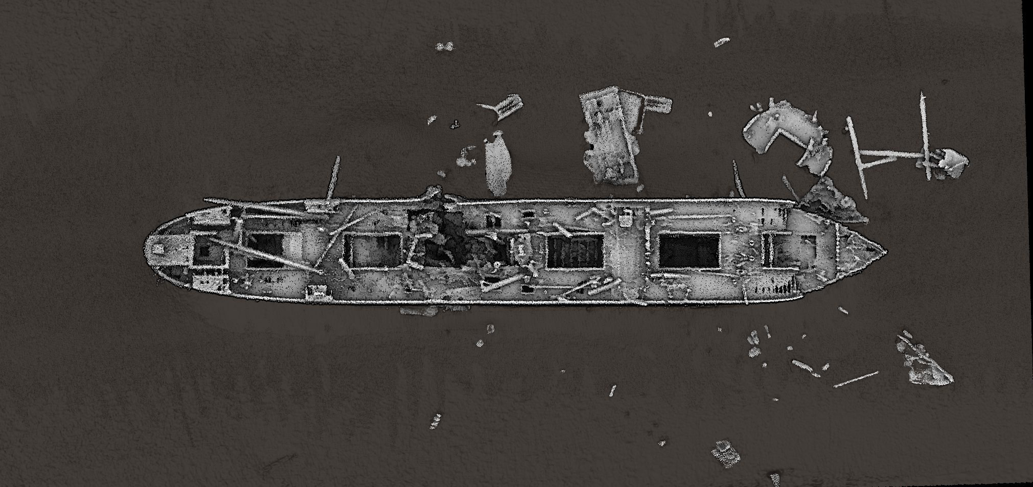
Survey of the SS Breda Ship Wreck
The SS Breda was a cargo ship, 123m in length, which sank during World War II. It rests on the seabed at approximately 26m depth. The above image shows raw point cloud data collected from multiple passes over the wreck.